
Library Record
Images
Metadata
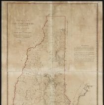
Title |
Topographical Map of the State of New Hampshire |
Call# |
M0053b |
Author |
Holland, Samuel, Esq. |
Object Name |
Map |
Object ID |
M0053b |
Publisher |
Printed for William Faden, Geographer for the King |
Published Date |
1784 |
Published Place |
London, Eng. |
Multimedia Files |
Click here to download the map from the Leventhal Map Center of the Boston Public Library. |
Summary |
Includes advertisement attesting to the fact that Samuel Holland rectified surveys froom"astronomical observations made by him at Portsmouth Wentworth House, Newburyport, Cape Anne, etc...." and further explains discrepancy in eastern boundary and some townships |
Subjects |
18th century New Hampshire Cartography Maps |
People |
Holland, Samuel, Surveyor, dfl. 1780 Grant, James, cartographer Wright, Thomas, d. c1754 |
Search Terms |
New Hampshire. |
Physical Description |
2 Negative images; 84m x 65cm; b&w |