
Library Record
Images
Metadata
Title |
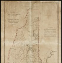
Topographical Map of New Hampshire |
Call# |
M0453 |
Author |
Holland, Samuel |
Object Name |
Map |
Object ID |
M0453 |
Publisher |
Faden, William |
Published Date |
1784 |
Published Place |
Charing Cross, London |
Multimedia Files |
Click here to download the map from the Leventhal Map Center of the Boston Public Library. |
Summary |
printed for William Faden, Geographer for the King Surveyed under the direction of Samuel Holland, Surveyor General of Lands for the Northern District of North America. by the following gentlemen: Messrs.Thomas Wright, George Sproule, James Grant, Thomas Wheeler, Charles Blaskowitz It is a printed version of the Grant map of 1761. |
Subjects |
Maps New Hampshire Topographic maps |
People |
Holland, Samuel, Surveyor, dfl. 1780 Grant, James, cartographer |
Search Terms |
New Hampshire |
Physical Description |
Framed print from digital file. |