Search Term Record
Metadata
Name |
Dover (N.H.) |
Details |
Dover is the oldest continuous settlement in New Hampshire (1623) and the seventh oldest in the United States. The permanent settlement occurred in what is now the Dover Neck area. For a few years Dover was an independent colony named Northam. In 1692 Northam became part of the Massachusetts Bay Colony. The original township of Dover included the present towns of Dover, Durham, Lee, Madbury, Somersworth, Rollinsford, and parts of Newmarket, Newington, and Greenland. |
Number of Archive records |
35 |
Number of Library records |
167 |
Number of Object records |
0 |
Number of Photo records |
55 |
Related Records
-
AD028 - Portsmouth and Dover Railroad Survey blueprints, undated
Blueprints pertaining to the Boston and Maine Railroad Eastern Division route between Portsmouth and Dover, New Hampshire. Undated. Concerns the resurvey of 1902-1905. Shows tracks, land acquisition parcels, names of homeowners and businesses, and railroad structures. Twenty-five sheets on one continuous roll. Each sheet measures 18 x 30 in. Scale: 1 in. = 100 ft.
Record Type: Archive

-
AD029 - Portsmouth and Dover Railroad blueprints, c1933
Blueprints pertaining to the Boston and Maine Railroad Eastern Division route between Portsmouth and Dover, New Hampshire. Dated circa 1933. Shows parcels of land that the railroad crosses with landowners' names, geograhical locations, and street names. From an original blueprint drawn by Johnson in 1874. Traced by W. E. R. Wells, 1895-1896. Sixteen sheets on one continuous roll. Each sheet measures 18 x 30 in. Total height: 36 in. Scale: 1 in. =...
Record Type: Archive
-
-
An account of the numbers that have died of the distemper in the throat, within the province of New Hampshire, with some reflections thereon. - BX9843 .F57
Ftich, Jabez, 1672-1746.
Record Type: Library
-
-
-

-
-
-
-
-
Bavicchi Ephemera Collection, January-December, 1961. - E 2607 B01 F08 (January-December, 1961)
Record Type: Library
-
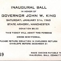
Bavicchi Ephemera Collection, January-December, 1963. - E 2607 B01 F10 (January-December, 1963)
Record Type: Library
-
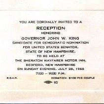
Bavicchi Ephemera Collection, July-December, 1968. - E 2607 B02 F02 (July-December, 1968)
Record Type: Library
-
Bed hangings : a treatise on fabrics and styles in the curtaining of beds, 1650-1850 / compiled by Abbott Lowell Cummings ; essay by Nina Fletcher Little ; new introduction by Jane C. Nylander. - Professional Collection - Curatorial
Cummings, Abbott Lowell
Record Type: Library
-
-
-
-
-